Palmerston North sits on the deep alluvial gravels of the Manawatu River floodplain, where the water table often rises within two metres of the surface and the regional seismicity demands more than a standard borehole log. Our team runs seismic tomography surveys here because the contrast between the loose Holocene silts and the compact greywacke gravels at depth creates velocity boundaries that refraction alone can miss. When a site straddles the terrace edge near Fitzherbert Avenue, for instance, we routinely pair the tomography with CPT testing to calibrate shear-wave velocities against tip resistance, and with MASW profiling to build a continuous Vs30 model across the entire footprint. The result is a ground model that the structural engineer can use directly for site-specific response analysis under NZS 1170.5.
The velocity boundary between loose alluvial silt and the underlying greywacke gravels is often the single most important interface for foundation design in the Manawatu.
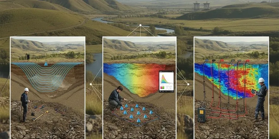
Technical details of the service in Palmerston North
Critical ground factors in Palmerston North
Palmerston North recorded peak ground accelerations exceeding 0.25 g during the 2014 Eketahuna earthquake, and the city’s 88,000 residents live atop a sedimentary basin that can amplify long-period motion. The biggest risk we see on commercial projects is assuming homogeneous gravels when the tomography reveals a wedge of soft silt lensing out at 8–12 m depth, right where pile toes would bear. A velocity inversion — where a low-velocity layer sits beneath a faster cap — fools a simple refraction interpretation but shows up clearly on a full tomographic inversion. We also run the survey along two perpendicular lines whenever the structure exceeds three storeys, because a 1D Vs profile from a single spread cannot capture lateral variability under a raft foundation. The tomography data feeds directly into a liquefaction assessment when the groundwater is shallow and the fines content of the near-surface soils is above 15 percent.
Our services
Every seismic tomography campaign in Palmerston North is designed around the specific geotechnical question — whether it is mapping rockhead for a piled foundation, imaging a suspected sinkhole, or measuring Vs30 for a site classification. The three service packages below cover the most common requests from structural and civil engineers in the region.
2D Refraction Tomography for Foundation Design
Multi-shot refraction profiling with ray-based inversion to delineate soil/rock interfaces and identify low-velocity zones. Delivered as a depth section with annotated velocity contours ready for input into PLAXIS or FLAC models.
Combined Refraction and Reflection Survey
Single-spread acquisition that captures both the critically refracted arrivals and the near-vertical reflections from deeper impedance contrasts. Useful for sites where bedrock lies beyond the penetration limit of a standard refraction spread.
Vs30 Mapping for Seismic Site Classification
Parallel seismic lines analysed for shear-wave velocity via surface-wave inversion, providing a site-wide Vs30 map compliant with NZGS guidelines for site subsoil classification under NZS 1170.5.
Frequently asked questions
How long does a typical seismic tomography survey take on a Palmerston North site?
A single 115 m refraction line with 48 channels and an accelerated weight drop source takes our crew about three hours on site, including the initial walkover and cable layout. A combined refraction-and-reflection spread with 72 channels usually finishes within a single working day. The final processed sections and the Vs30 report are typically delivered five to seven working days after acquisition, though we can expedite the draft velocity models if the foundation contractor is waiting on the data.
What depth of investigation can seismic tomography reach in the Manawatu gravels?
With a 230 m spread and a weight-drop source, we routinely image the top 50–60 m in the dense greywacke gravels beneath Palmerston North. The high P-wave velocity of the saturated gravels — often above 1,600 m/s — actually helps because it creates a strong impedance contrast with any overlying silt or fill. If bedrock is deeper, we switch to a reflection processing workflow that can map horizons beyond 80 m, provided the acoustic contrast is sufficient.
What does a seismic tomography survey cost for a typical commercial site in Palmerston North?
For a single-line refraction tomography survey with 48 to 72 channels, the fee ranges between NZ$4,460 and NZ$9,630 depending on the spread length, the source type required, and whether reflection processing is added. A two-line campaign for a multi-storey structure falls toward the upper end of that range. Every quote includes mobilisation within the Manawatu region, the final velocity sections, a written interpretation report, and the digital SEG-Y files.