The Manawatu River floodplain shapes much of the ground beneath Palmerston North, with deep alluvial silts, sands, and occasional gravel lenses deposited over the past 18,000 years. These young Quaternary sediments rarely have a uniform grain size distribution—a borehole log from Kelvin Grove may show well-graded gravel while a site near the lagoon at Hokowhitu reveals a gap-graded silty sand prone to internal erosion. Determining the full particle size range requires a combined sieve and hydrometer analysis, and that is exactly what a grain size program delivers for earthworks design and liquefaction screening. The city averages 960 mm of rainfall annually, so moisture-sensitive fines content matters when specifying compaction targets or assessing drainage potential. A particle size distribution curve—from coarse gravel down to the clay fraction—allows the geotechnical engineer to classify the soil according to the NZGS field description system and to select appropriate parameters for settlement, permeability, and strength models. Without this data, assumptions about the soil fabric remain speculative, and that introduces unnecessary risk into foundation design, retaining structures, and road subgrades across the Manawatu.
A single grading curve from 75 mm down to 2 microns replaces a dozen assumptions about how the ground will drain, compact, and behave under seismic load.
Technical details of the service in Palmerston North
Critical ground factors in Palmerston North
The rotary sieve shakers and sedimentation cylinders used for particle size analysis in our Palmerston North laboratory are calibrated against reference sands and glass bead standards to maintain repeatability across projects. A poorly graded sand with a uniformity coefficient below 3, common in river terrace deposits near the Manawatu Gorge, can look competent in a split-spoon sample but will densify rapidly under cyclic shear, losing strength and shedding pore pressure. The hydrometer reading captures the <10% fines that might flip a soil from ‘potentially liquefiable’ to ‘non-liquefiable’ under the NZGS-MBIE seismic guidelines, a distinction that carries enormous cost implications for ground improvement. Equally, a gap-graded gravelly sand makes a poor filter material around drainage pipes because the missing intermediate particle sizes allow fine silt to pipe straight through the voids. The grading curve quantifies that vulnerability before the aggregate arrives on site, saving rework on subsoil drainage systems that would otherwise clog within the first wet winter.
Our services
The grading analysis program is configured to match the soil conditions encountered in the Manawatu—from coarse river gravels to soft estuarine silts. Each service package includes sample preparation, quality control checks, and a signed report with the full grading curve and derived parameters.
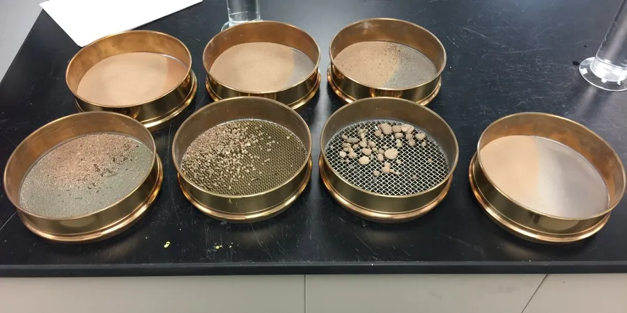
Sieve Analysis (Coarse + Fine)
Mechanical shaking through a stacked sieve column from 75 mm down to 75 μm. Washed and dry-sieved fractions reported separately to avoid fines loss. Applied to subgrade soils, concrete aggregates, and drainage filter materials.
Combined Sieve & Hydrometer
Full particle size distribution from gravel to clay fraction. Hydrometer readings taken at 0.5, 1, 2, 5, 15, 30, 60, 120, and 1440 minutes, temperature-corrected and plotted with the sieve data on a semi-logarithmic chart.
Pipette or Laser Diffraction (Supplemental)
For projects requiring ultra-fine resolution below 2 μm, such as clay mineralogy studies or reservoir siltation assessments, we offer supplementary analysis by pipette method or laser particle sizer, calibrated against the hydrometer baseline.
Frequently asked questions
What is the difference between a sieve-only and a combined sieve-plus-hydrometer analysis?
A sieve-only analysis stops at 75 μm and reports everything finer as 'passing 75 μm' without distinguishing silt from clay. A combined analysis continues with a hydrometer sedimentation test that measures particle sizes down to about 2 μm, giving a full breakdown of the silt and clay fractions. This distinction is critical for USCS classification, Atterberg limits correlation, and liquefaction susceptibility screening under NZGS guidelines.
Do you use sodium hexametaphosphate as a dispersant for the hydrometer test?
Yes, a sodium hexametaphosphate solution is added to the soil suspension prior to the hydrometer test, following NZS 4407 Test 3.9 procedures. The dispersant deflocculates clay particles so they settle as individual grains rather than as flocs, ensuring the sedimentation velocity reflects true particle size rather than aggregate behaviour.
What does a grading analysis cost for a typical Palmerston North residential site?
For a combined sieve and hydrometer analysis on a single sample, the fee ranges from NZ$200 to NZ$300 depending on the number of sieve sizes requested and whether a full report with classification and grading envelope compliance is needed. Multiple samples from the same borehole or test pit reduce the per-sample cost.
How long does it take to get results from a hydrometer analysis?
The hydrometer sedimentation phase alone requires a minimum of 24 hours to capture the fine clay readings, and often extends to 48 hours for temperatures below 20°C. Including sample preparation, sieve shaking, data reduction, and report drafting, a combined sieve-plus-hydrometer report is typically delivered within three to four working days of sample receipt.