Palmerston North sits on deep alluvial deposits of the Manawatu River floodplain, where soft silts and sands extend tens of metres below ground level before reaching competent rock. This geology, combined with the city's location on the Pacific Ring of Fire, means that seismic site response can amplify ground motion significantly during a major rupture on the Wellington or Hikurangi fault systems. A standard N-value investigation rarely captures the full picture when the subsoil profile is this thick and variable. Our laboratory team runs MASW surveys to extract a continuous shear wave velocity profile, which feeds directly into a VS30 calculation and makes the site classification under NZS 1170.5:2004 a measured quantity rather than a conservative assumption. When the near-surface geology includes interlayered peat lenses—common in parts of Awapuni and Milson—a seismic refraction line can be added to constrain the P-wave velocity model and improve the inversion reliability in the top 5 metres.
When the water table sits at 1.5 metres and the fines content is above 35 percent, blow-count correlations for Vs are no longer reliable—a direct MASW measurement becomes the only defensible path.
Technical details of the service in Palmerston North
Critical ground factors in Palmerston North
The Manawatu River has migrated across the floodplain over the Holocene, leaving behind abandoned channels filled with soft, compressible organic silts that are invisible from the surface. In a Level 2 seismic assessment under the NZSEE guidelines, a site classified as Class D instead of Class C can increase the design base shear enough to trigger a costly retrofit on an existing building. Our team has surveyed sites along Rangitikei Street and College Street where the Vs30 varied by more than 60 m/s over a distance of 200 metres, purely because the array crossed an infilled paleochannel. Without a direct shear wave velocity measurement, that lateral variability stays hidden. We run the full analysis according to the NZGS Earthquake Geotechnical Engineering Practice guidelines, including the Vs30 calculation, the fundamental site period estimate, and the horizontal-to-vertical spectral ratio when microtremor data is available.
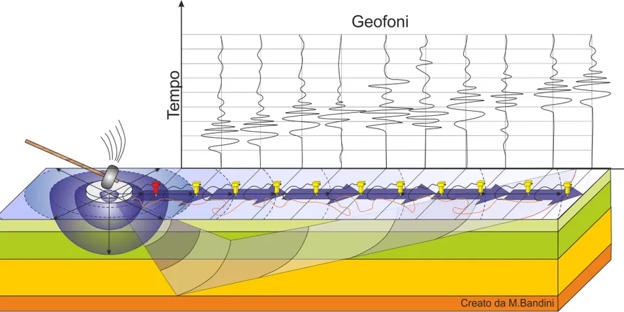
Our services
The MASW service in Palmerston North is configured around the specific site classification needs of seismic assessments and foundation design on the Manawatu floodplain. We adjust the array geometry and source energy based on the expected depth to the 30-metre Vs horizon, and we handle the traffic control and Council notification when the survey line runs along a public road.
VS30 Site Classification Survey
Complete MASW acquisition and processing package delivering a Vs profile, Vs30 value, and site class per NZS 1170.5 Table 3.1, ready for submission with a building consent application.
Combined MASW and Seismic Refraction
Dual-array survey that constrains both P-wave and S-wave velocity models, improving the Vs30 accuracy when the water table is shallow and the bedrock interface is gradational.
Paleochannel and Lateral Variability Mapping
Multiple MASW lines on a grid to identify buried channels and map lateral changes in Vs30 across a development site before foundation layout is finalised.
HVSR and Fundamental Period Measurement
Single-station microtremor recording processed to extract the horizontal-to-vertical spectral ratio, providing a secondary estimate of the fundamental site period for comparison with the MASW-derived value.
Frequently asked questions
What is the typical cost of a MASW survey for a residential site in Palmerston North?
A single 46-metre MASW line on a standard residential section in suburbs like Awapuni or Takaro typically runs between NZ$2,800 and NZ$5,520, depending on access conditions, the number of shot points required, and whether traffic management is needed if the array extends onto the road reserve.
How does a MASW survey differ from SPT blow counts for site classification?
MASW measures shear wave velocity directly by analysing surface wave dispersion, whereas SPT correlations estimate Vs from blow counts using empirical equations. On the silty sands of the Manawatu floodplain, those equations carry significant uncertainty, and the NZGS guidelines acknowledge that a measured Vs profile is always preferred when the site falls near a class boundary.
What depth of investigation can I expect in Palmerston North soils?
With a 46-metre geophone spread and a 10 kg sledgehammer source, we routinely obtain usable dispersion data down to 25–30 metres in the alluvial deposits typical of the city. If the client needs a deeper profile for a specific project, we can extend the array length or use a heavier energy source, though the standard configuration is sufficient for the VS30 calculation required by NZS 1170.5.